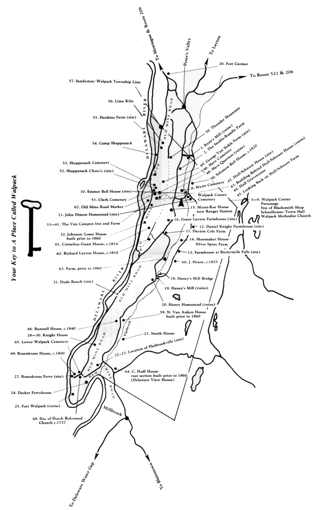
Van Campen Inn
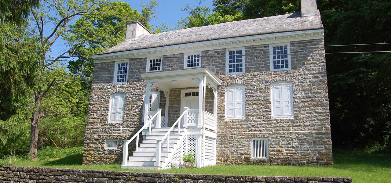 Originally built as a farm house, this building was designated a “Yaugh” house during Colonial times when it became common practice to offer homes as shelter for travelers. The farm was considered a self-sufficient plantation with animals and a blacksmith shop. The flood plain, between the house and river, provided rich land for farming. Slaves were kept by the various owners to help with the work.
The original section, built before 1750, was removed in 1917. In 1984 due to structural problems, the National Park Service did extensive stabilization and restoration to the building.
 The area played an important part during the French and Indian War and during the American Revolution. Referred to by General George Washington as the frontier, the area supported a series of block houses and forts to protect the citizens against Indian attack. Located nearby is the site of Fort Shapanack.
Google Map to find the Van Campen Inn
Buttermilk Falls
Buttermilk Falls is the highest waterfall in the state of New Jersey at approximately seventy-five feet. If you climb the steep stairs to the the top of the falls and walk a short distance; you will reach the Walpack Mine. The entrance is a cave-like opening and is now nearly filled-in by the motion of the stream.
Walpack Centre Store and Post Office
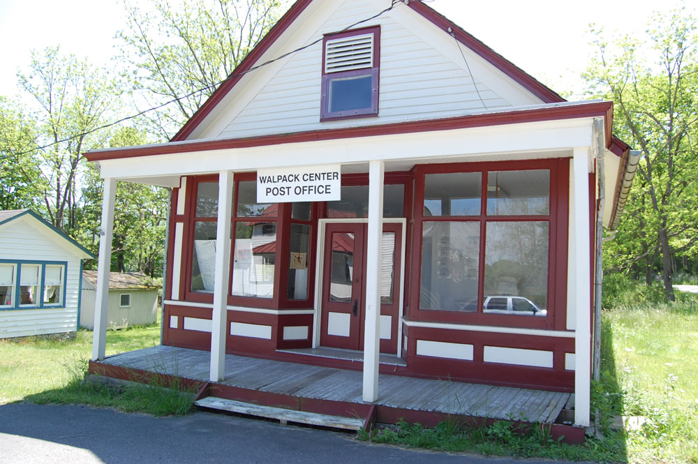 A small store had previously existed for a few years starting in 1825 half a mile south on the east side of the Flatbrook in the area of the cemetery. The store was kept by James Vardakin, the building being owned by his father-in-law, Ira Fuller. Vardakin was succeeded in 1828 by George W. Lane and William Stoll.
According to Snell’s History of Sussex & Warren Counties “Isaac S. and Jasper W. Rundle, who had previously kept a store in the old Rosenkrans storehouse, at Stoll’s, opened the first store at Walpack Centre in 1850. Ira Fuller had twenty-five years before kept a store near the old Dimon place; the locality was then known as Pleasant Valley.”
It should also be noted that the first post office in Walpack Township was established at Flatbrookville in 1828 with Jacob Smith as postmaster. In 1829, another post office, called Walpack, was opened in the Pleasant Valley/Walpack Center area, with Daniel Shoemaker serving as postmaster. It was possibly located in the springhouse on the Shoemaker property, now known as Silver Spray Farm. This P.O. was in operation until 1844.
In 1854, several years after the Rundles opened their store, the post office at Wallpack Centre was established with Jasper W. Rundle serving as postmaster. It could have possibly been called Pleasant Valley post office if not for the fact that New Jersey and Sussex County already had a Pleasant Valley P.O. over by Baleville. Thus came the name Wallpack Centre.
The Walpack Center Store/P.O. building is actually the second at this location. The original 2-story general store building burned in 1915, and was quickly rebuilt as the 1 ½ story structure which now exists. Over time this building has had a couple of additions or extensions which have since been removed.
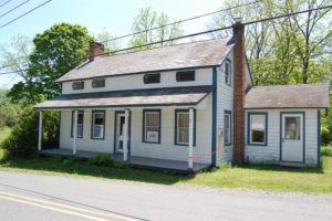 Rosenkrans House & Museum
This house is one of the oldest buildings in Walpack Center. Built in 1850 by Jasper Rundle, the house is built in the Delaware Valley style of architecture. The house has eyebrow windows and had winder stairs from attic to cellar. Today this home is a small museum and the local headquarters for the Walpack Historical Society. It is open to the public on Sundays from May to October as volunteer schedules permit.
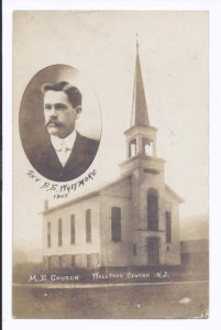 Walpack Methodist Church

This well-built church was erected in 1872 at its present site at a cost of seven thousand dollars. The land on which it was built was donated by Jacob and Sarah Roe. This tall, white frame building has arched windows and displayed a tall steeple which has since been removed. The ceiling rises 20 feet high. The ceiling and interior walls are decorated in a “trompe l’ oeil” style (meaning ”fool the eye) to add depth. Today, the church is owned by the National Park Service. The Walpack Historical Society uses this facility for its general meetings.
Fundraiser to Renovate the Walpack Methodist Church
 HANEYS MILL
Haneys Mill is a section or locale of Walpack Township about a mile or so north of Flatbrookville. There was a gristmill here by 1860. It appears on the Sussex County wall map of that year with a nearby sawmill, a lime kiln, and residences of C. Haney, J.W. Fuller and B.D. Fuller. James P. Snell’s History of Sussex & Warren Counties of 1881 refers to Haney’s Mill. Serving at various times as a gristmill, a sawmill and a cidermill, the last operator was Jake Haney. By 1950 the mill was in a fairly tumbledown condition, and the hurricane of that year brought an end to it. Bits of the stone foundation walls and the dam can still be seen.
The mid-nineteenth century farmhouse of the Haney family also stood nearby. Some of the scenes from the 1933 Ford Motor Company promotional film “These Thirty Years” were filmed here. In the movie, the place was known as the Haines farm; across the road in front of the house were the barns where the auction scene was filmed.
The nearby Haney’s Mill iron bridge crossing the Flatbrook dates back to 1891.
In 2008, the section was designated as the Walpack Wildlife Management Area, which is administered under the N.J. State Division of Fish and Game.
 MILITARY TRAIL
In the middle of the 18th century, the area along the upper Delaware River was the frontier. With ever increasing numbers of British settlers coming to the area, tensions erupted with the native Delaware Indians, who had recently declared themselves independent of the British allied Iroquois Indians.
In November 1755, Indian attacks at the Moravian settlement of Gnadenhutten (Lehighton, Pa.) and at Stroudsburg, Pa. alarmed Col. Abraham Van Campen of Pahaquarry (then in Walpack Twp.), who notified New Jersey Governor Belcher. In December, Gov. Belcher met with the New Jersey General Assembly, and enacted a law procuring ten thousand pounds in bills of credit for erecting a series of forts or blockhouses along the upper Delaware, and for supplying a number of forces to man the forts.
Initially four forts were built: Fort Reading at Belvidere, N.J.; Fort Van Kamps, near the home of Col. Van Campen (18 miles north of Fort Reading); Fort Walpack, at the Walpack Bend (6 miles above Fort Van Kamps); and Fort Shapanack or Johns, also known as Headquarters, on the property of Col. John Rosenkrans (6 miles above Fort Walpack). This last was located on the hill above and overlooking the Van Campen Inn. Eventually, the number of forts would be increased to 14.
Jonathan Hampton, a surveyor and land speculator from Elizabethtown, was appointed paymaster and quartermaster, as well as victualer or commissary of the troops. He was thus responsible for supplying food for the frontier guard as well as for paying them.
As there was no direct road from the upper Delaware to Elizabethtown, where most of the supplies would be coming from, Hampton decide to build one. In his notes, he refers to it as the “Military Supply Road”. The road starts at the Old Mine Road, by the Van Campen Inn, goes over the mountain, thru Walpack Center, across the Flatbrook, up thru Tillmans Ravine, over Brinks Road to Mecca Lake, thru Myrtle Grove, Baleville and Halsey, then down what today is Rt. 519 to present day Newton. It then follows present Rt. 206 to Netcong, then Rt. 46 to Ledgewood, then east on Route 10 and South on Mt. Freedom Rd. to Morristown. From that point to Elizabethtown, a good road already existed. At the time the road was first built in 1756/1757, none of the towns between the Old Mine Road and Morristown existed. Newton did not come into existence until 1765 as Sussex Court House, when a courthouse was built there. Thus, this was truly the frontier.
The Military Trail that runs over the mountain between Walpack Center and the Old Mine Road is the last mile of the original “Military Supply Road” that Jonathan Hampton built from Morristown in order to bring supplies from Elizabethtown to the Frontier Guard along the upper Delaware River during the French and Indian War.
Source: This is a paraphrasing of an article on Jonathan Hampton written by Leonard Peck in Nov. 1997 issue of the Walpack News.